Geofencing has long been used by carriers to track shipments, assets and employees but has more recently evolved to offer better insights via data in an industry that is relatively new to using data as a whole.
For example, Trucker Path has used geofencing to amass about 20,000 parking locations where drivers can park their trucks safely and legally by gathering data on space availability from users when they cross that digitally drawn fence around a specific geographic area. It also asks drivers about wait time at shipping facilities so drivers have an understanding or expectation based on people who were there before them and can plan accordingly.
“It really helps to drive efficiencies because it gives you a look forward as a driver, which then rolls up to the fleets,” said Chris Oliver, chief marketing officer at Trucker Path.
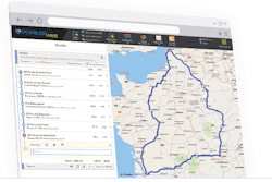
Those efficiencies are important in a time of resource scarcity and higher prices. Trimble Maps recently introduced updated geofencing technology to add precision in pinpointing commercial locations like warehouses to improve efficiency.
Trimble began working on its polygonal Places Data in 2019, launching initially as a small library of locations. The company has since identified a larger number of locations and higher volume of data and released an expanded version this year.
Geofences have traditionally served as simple wide-radius circles around an address, triggering automated arrival notifications and driver alerts a mile or so away from a driver’s actual destination. Trimble’s enhanced Places Data added more accurate, useful data points to millions of commercial locations across the U.S., such as which service road or entrance a driver should use, reducing delays due to incorrect directions and risky driving behaviors caused by stress and confusion.

